within 5 minutes to merano
Close to the Spa Town

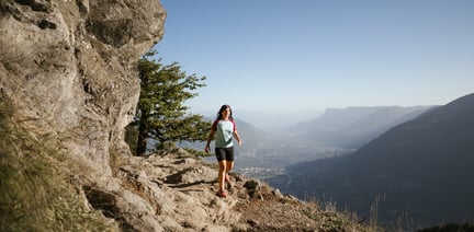
Especially on warm days, the Marling mountain road is an ideal hiking path particularly on warm days, along the North-Eastern slope of the Marling mountain.
The hydroelectric power station in Töll/Tel, the starting point of the hike, is reachable by bus 213. You first take the Marling Waalweg canal trail until the junction of the trail leading to the Marlinger Höhenweg high alpine trail. You walk slightly uphill to the Rastbichler Hof farm and then eastwards along a wider access road until the Marlinger Höhenweg high alpine trail branches off again and leads past the Buchlechner Hof farm to the Senn am Egg inn. Accompanied by a beautiful view of the Burggrafenamt/Burgraviato, the surrounding villages and mountain peaks, the route continues through mixed forest, past mountain farms and leads to an asphalt road that takes you down to Marling/Marlengo. At the junction with the Marling Waalweg canal trail, you can return to Algund/Lagundo along the canal trail or take the bus or train.
Parking lot next to the outdoor swimming pool Lido at Algund.
By bus line 212 to the Forster Steg at Algund.


The Spronser lakes are located at the centre of the Texel Mountain Nature Park, one of the largest high mountain lake districts in the entire Alps. They are filled with ...

High above Partschins/Parcines sits the well-known local mountain of Partschins/Parcines, the Zielspitze summit!
The three-thousand-metre peak is the first peak in ...